The Church of the Fathers
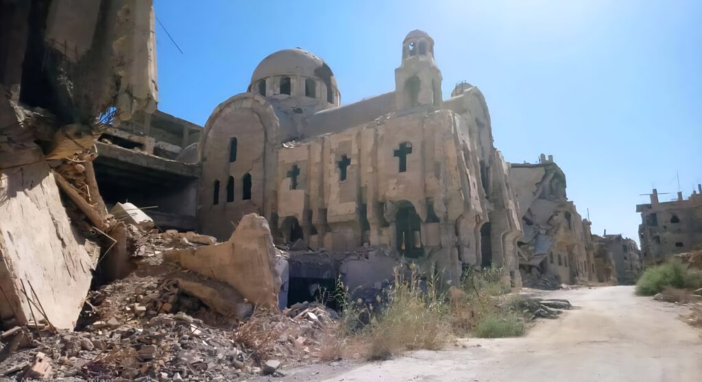
The establishment of the Capuchin Mission in Deir ez-Zor dates back to the early 20th century, with the Latin Catholic Church known as the Capuchin being one of the oldest churches in Deir ez-Zor. Its current structure was built in 1930. The church includes a monastery and a home for the elderly named after Mother Teresa. The Capuchins focused on providing humanitarian and educational services alongside religious activities, founding a school and library affiliated with the church, which significantly contributed to improving education among local residents regardless of religious affiliation. The church features a simple design reflecting Franciscan monasticism, incorporating elements that embody an Eastern character, such as small domes and ornate windows. It was destroyed by gangs affiliated with the former regime, who sought to erase cultural and religious identities; however, it holds a special place in the hearts of both Christian and Muslim residents of the province.
Al-Furat School (or The Euphrates School)

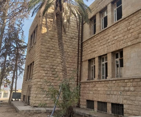
A secondary school in the city of Deir ez-Zor, built in 1910, and considered one of the oldest schools in the eastern region of Syria. The Euphrates Secondary School is recognized as the oldest educational institution in eastern Syria and among the oldest in the country. Its construction is regarded as one of the earliest buildings in Deir ez-Zor, initiated at the request of the governor Muhammad Rashid Pasha during the late reign of Ottoman Sultan Abdul Hamid II. Upon its inauguration, it was named the Sultan’s Office, with Turkish being the primary language of instruction alongside Arabic, as well as two secondary languages: French and English. The teaching staff included several Turkish instructors in addition to local residents. During the French occupation, the curriculum was altered to align with the French educational system, encompassing both preparatory and secondary stages, and it was renamed Euphrates Secondary School. The school became a constant venue for protests and political struggles and is still regarded as the premier educational institution in the province to this day. The Amir of Education for the Deir ez-Zor district, Moharram Effendi, selected the school’s location on the western edge of the city, specifically in the southwestern area of the Rashidiya neighborhood. Construction began, establishing it as the first of its kind in eastern Syria, taking approximately two and a half years to complete. In 1920, the first phase of expansion commenced, concluding in 1924, followed by a second phase starting in 1940. The building, which still stands today, was designed to resemble the Arabic numeral forty, in reference to the year of its expansion. In 2007, several restoration and maintenance projects were carried out on the school, leading to its inclusion by the General Directorate of Antiquities and Museums as part of the heritage buildings.
Tell Hariri (or Hariri Hill)

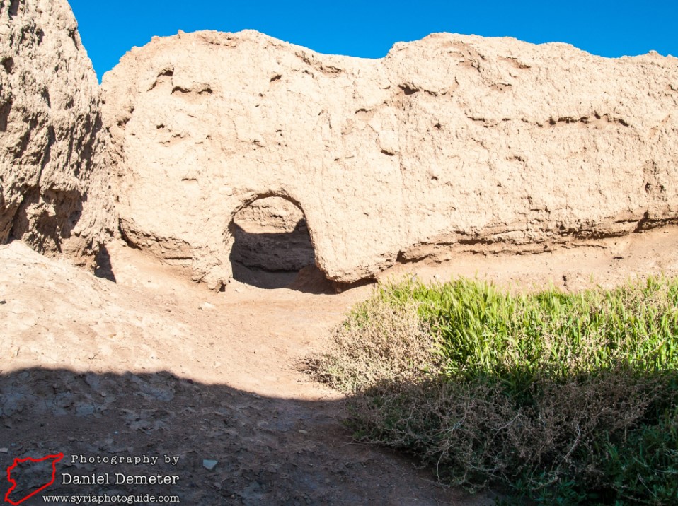
Mari (Tell Hariri) is an archaeological site of exceptional significance, located approximately 11 kilometers northwest of Al-Bukamal on the right (western) bank of the Euphrates River, and about 115 kilometers south of Deir ez-Zor. Positioned along the ancient trade route between the Mediterranean Sea and Mesopotamia, Mari’s strategic location granted it immense geographic importance and economic prosperity. Its status as a commercial hub drew the attention of rival kingdoms, ultimately leading to its conquest by Hammurabi of Babylon. Mari played a crucial role in ancient international trade and was a major center for the bronze industry, with large quantities of bronze imported through trade routes connecting Mari to Iraq and Aleppo. The site was once the capital of a prominent Semitic kingdom in what is now Syria, flourishing between 2900 BCE and 1759 BCE. Due to its location on the Euphrates, Mari served as a vital intermediary between the Sumerian civilization in the south and the kingdom of Ebla and the broader Levant to the west. The site was discovered in 1933, near the Iraqi border in eastern Syria, when a local Bedouin tribe unearthed a headless statue while digging in Tell Hariri in search of a tombstone. Upon notification, the French Mandate authorities initiated archaeological excavations, which officially began on December 14, 1933, led by a team from the Louvre Museum in Paris. Initial excavations revealed the Temple of Ishtar, paving the way for broader digs. Archaeologists have since classified Mari as the westernmost outpost of Sumerian culture. Over 25,000 clay tablets written in Akkadian cuneiform script were uncovered, offering invaluable insights into political, economic, and religious life in the ancient Near East. Artifacts from Mari are now housed in institutions such as the Louvre Museum, the National Museum of Aleppo, the National Museum of Damascus, and the Deir ez-Zor Museum. One of the notable restoration efforts at the site included the reconstruction of the southern façade of the “Palm Court” within the Palace of Zimri-Lim, including its painted wall panels. However, excavation work ceased in 2011 due to the outbreak of the Syrian civil war and has not resumed since. The site fell under the control of armed groups and suffered extensive looting. A 2014 official report revealed that looters had targeted key structures, including the Royal Palace, the public baths, the Temple of Ishtar, and the Temple of Dagan. Satellite imagery confirmed that looting activities continued at least until 2017.
Qal’at al-Rahba (or Al-Rahba Fortress/Castle)

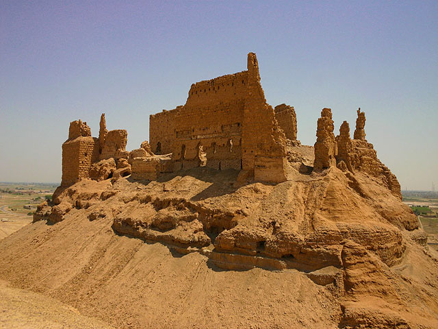
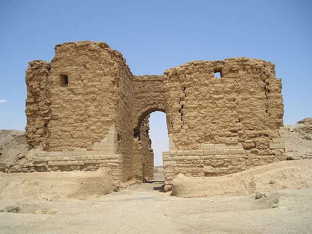
Rising majestically on the banks of the Euphrates River near the city of Al-Mayadin in eastern Syria, Qal’at al-Rahba (The Citadel of Rahba) stands as a monumental reminder of the region’s layered history. Geographically, the site lies at longitude 40.5° E and latitude 35° N, strategically positioned between the ancient cities of Deir ez-Zor to the north and Dura-Europos (Salhiyah) to the south. The surrounding area is often referred to as Rahbat al-Sham or Rahbat Malik ibn Tawk, a name derived from the prominent Arab leader Malik ibn Tawk al-Taghlibi, who is credited with building the current structure of the fortress during the reign of the Abbasid Caliph al-Ma’mun, around 854 CE. The citadel was constructed to serve both administrative and military purposes, safeguarding this vital point along the Euphrates frontier. Historical sources and Arab chronicles mention the older settlement as Furdat Nu‘m or simply al-Furda, indicating its long-standing significance as a river port and trading center. The original city of Rahba, located on the right bank of the Euphrates, played a key role in the communication and defense systems of the region. However, on August 12, 1157, a devastating earthquake struck the region, heavily damaging the cities of Rahba, Hama, and others in its path. Despite such natural disasters, the fortress has remained a symbol of resilience, reflecting the architectural and political heritage of medieval Islamic Syria.
Al-Salihiyah

Dura-Europos—modern-day Al-Salihiyah—is an important archaeological site located in the Syrian Desert near Deir ez-Zor. The city is home to the world’s oldest known house church, as well as some of the most exquisite frescoes ever discovered in a Jewish synagogue. Originally a Babylonian settlement, Dura-Europos became part of the Achaemenid Persian Empire following the fall of Babylon to Cyrus the Great in 538 BCE. The city was later rebuilt by the Seleucids around 300 BCE and named Europos, after a city in Macedonia. In 165 CE, it was annexed by the Romans, who fortified it as a military outpost before it fell to the Sassanids in 256 CE and was subsequently destroyed. Although the city’s political control shifted among the Babylonians, Seleucids, and Romans, the local culture remained deeply influenced by Syriac and Palmyrene traditions. The Seleucids saw Dura-Europos as a strategic alternative to Palmyra, transforming it into the first major Syrian stop along the Silk Road, which connected China to the Mediterranean via Homs and the Syrian coast. The Mediterranean, once considered a Syrian sea, was not merely a conduit for trade but a crossroads of ideas, inventions, religious thought, and cultural exchange, facilitated by Syrian sailors and merchants. During the first three centuries of its development, Dura-Europos evolved into a vibrant cultural hub, where the civilizations of the ancient world converged. Its central location on the Silk Road made it a center for commerce, industry, and agriculture, as evidenced by its numerous administrative buildings surrounding a central marketplace, its expanded fortifications, and the presence of diverse temples and shrines throughout the city. Strategically located in the heart of the Syrian Desert, Dura-Europos is surrounded by three plateaus and a valley, offering a naturally fortified position. To the west, it overlooks the open Syrian steppe extending toward Palmyra, with which it maintained strong commercial, cultural, and military ties. Like many ancient cities, Dura-Europos was enclosed by fortified walls with watchtowers. Its most intact entrance today is the Palmyra Gate, while a second gate once faced the Euphrates River but has largely eroded due to environmental exposure. In its earliest days, Dura-Europos was not a major military center but rather a checkpoint guarded by a small garrison—likely affiliated with the administration of Palmyra—to secure caravan routes. The city spans roughly 1 km from north to south, and about 700 meters from the Euphrates to the desert wall, covering an area of nearly 50 hectares. Tombs were located west of the settlement, while service buildings and waste disposal areas lay outside the Palmyra Gate and city walls. Most of the uncovered ruins within the city walls date to the Roman period, during which the city was heavily fortified and served as a key defensive stronghold on the empire’s eastern frontier.
Tell Sheikh Hamad (or Sheikh Hamad Hill)

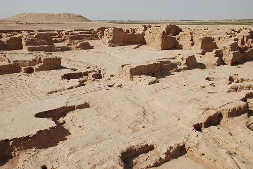
Dur-Katlimmu is a prominent archaeological site in Syria’s Deir ez-Zor Governorate, identified as the ancient Assyrian city, now known as Tell Sheikh Hamad, approximately 70 kilometers east of Deir ez-Zor on the eastern bank of the Khabur River. The site’s historical name was confirmed through cuneiform tablets discovered at the tell: in 1977, thirty tablets were unearthed in an irrigation canal, including one that explicitly identified Tell Sheikh Hamad as the city of Dur-Katlimmu. These texts date to the Middle Assyrian period, specifically during the reigns of Shalmaneser I (1274–1245 BCE) and Tukulti-Ninurta I (1244–1208 BCE). Strategically located atop a mound overlooking the river, Dur-Katlimmu was naturally shielded from flooding, enabling continuous habitation from the fourth millennium BCE to the present. The city reached its greatest extent during the Assyrian period (ca. 1300–600 BCE), encompassing an area of 110 hectares. Excavations began in 1978 by a German archaeological team from the Free University of Berlin, led by Professor Hartmut Kühne. The initial season revealed an archive chamber containing cuneiform tablets, later found to be part of a substantial architectural complex. Subsequent excavations uncovered ten rooms, measuring 40 meters in length and 20 meters in width, built of sun-dried mudbrick. The structure had suffered extensive fire damage but remained remarkably intact, with some walls preserved to a height of five meters, suggesting it may have once included a second storey. The site’s archive yielded over 600 cuneiform tablets, a significant number in archaeological scholarship. One key tablet mentions the deployment of military forces to Dur-Katlimmu, confirming the presence of a garrison and identifying the governor’s residence within the city palace. This directly affirms the site’s political and military significance, indicating that the Middle Assyrian Empire extended its frontier as far as the lower Khabur River in Syria. The city’s principal function was likely the protection of the empire’s southern border. During the Neo-Assyrian period (1000–600 BCE), Dur-Katlimmu remained a strategic military post situated along the route frequented by Assyrian kings. Archaeologists also uncovered clay tablets bearing seal impressions used by high-ranking officials, closely resembling those found in the archival chamber. This implies that goods stored in ceramic vessels were officially sealed and distributed within the palace, pointing to a highly organized administrative system. The art of seal engraving at the site is distinguished by striking visual scenes, such as a leaping winged bull and a guardian figure depicted as a winged deity, located at the city’s northeastern corner. Additionally, an exterior wall fortified with towers—dating from the 9th to 6th century BCE—was identified, alongside a facility that likely served as an arms depot or military barracks. All evidence confirms Tell Sheikh Hamad / Dur-Katlimmu as one of the most important archaeological sites along the Khabur River in Syria’s Jazira region—a location of exceptional historical depth, urban complexity, and imperial significance.
Sheikh Weis Tekiyeh (or Sheikh Weis Hospice/Dervish Lodge)

Tekkiyeh of Sheikh Wais—also known as the Great Naqshbandi Tekkiyeh—is a small mosque (zāwiya) situated in the heart of Deir ez-Zor, Syria. The term tekkiyeh is the Turkish equivalent of khanqah or zāwiya, though its etymology remains ambiguous. Some scholars trace it to the Arabic verb ittakā (to lean or rely on), aligning with the Turkish sense of rest and relaxation—a place frequented by wayfarers and travelers from nearby villages, where they would eat, drink, and sleep. The French orientalist Clément Huart suggested a Persian origin, linking the word to leather, recalling the Sufi sheikhs’ use of sheepskin and other hides as spiritual emblems. Named after Sheikh Muhammad Uwais al-Naqshbandi, son of Sheikh Ahmad al-Azzi al-A‘raji al-Husayni (reverently known as Sheikh Ahmad the Great), the tekkiyeh was constructed in 1885. It was succeeded by his descendants—first his son Sheikh Abdul Jalil, and later Sheikh Iyad al-Azzi al-Naqshbandi, who became a prominent figure in civic life, serving as the Mufti of Deir ez-Zor and Director of Awqaf. The Tekkiyeh of Sheikh Wais is the oldest tekkiyeh in Deir ez-Zor. It was built in 1885 by Sheikh Ahmad al-Azzi al-Naqshbandi the Great, who had a close relationship with Sultan Abdul Hamid, from whom he received gifts of carpets and chandeliers for the tekkiyeh. The structure covers an area of 562 square meters. Its walls were constructed from limestone and black plaster, while the domes were built using evenly cut soft stone. The columns resemble marble milestones, topped with capitals carved in the shape of delicate leaf motifs.
Sheikh Abdullah Tekiyeh (or Sheikh Abdullah Hospice/Dervish Lodge)

Tekkiyeh of Sheikh Abdullah—known as the Small Naqshbandi Tekkiyeh—is a modest mosque (zāwiya) located in central Deir ez-Zor, Syria. The term tekkiyeh, a Turkish analogue to khanqah or zāwiya, has contested origins. Some scholars trace it to the Arabic verb ittakā (“to lean or rely on”), particularly as the Turkish meaning evokes notions of rest and relaxation—a place where travelers and wayfarers from nearby villages could rest, eat, drink, and sleep. French orientalist Clément Huart proposed a Persian etymology, linking the word to leather, recalling the symbolic use of sheepskin by Sufi masters as a mark of humility and spiritual identity. This tekkiyeh was named after Sheikh Abdullah al-Naqshbandi, son of Sheikh Ahmad al-Azzi al-Naqshbandi (known as Sheikh Ahmad the Younger). It is situated on Tekkiyeh Street, the main avenue in the Hamidiyah district, approximately 300 meters from the Tekkiyeh of Sheikh Wais, to which it bears close architectural resemblance in terms of domes, columns, chambers, and the central hall. Constructed of limestone, soft stone, and local plaster, it ranks as the third-oldest tekkiyeh in Deir ez-Zor, following Tekkiyeh of Sheikh Wais and Tekkiyeh al-Rawi. Built in 1906—with the minaret added in 1978—the tekkiyeh was built by Sheikh Ahmad al-Azzi al-Naqshbandi the Younger. Its prayer area features a mihrab and minbar, and the structure includes three rooms, one of which houses the tomb of its founder. Additional elements include an iwan, a courtyard for prayer, and a stone staircase leading to the upper floor, which consists of two rooms and a hall. In 2004, the tekkiyeh—excluding the minaret—was officially registered as an Islamic heritage landmark by the governorate, preserving its legacy within the cultural and architectural narrative of Deir ez-Zor.
Al-Rawi Tekiyeh (or The Rawi Hospice/Dervish Lodge)

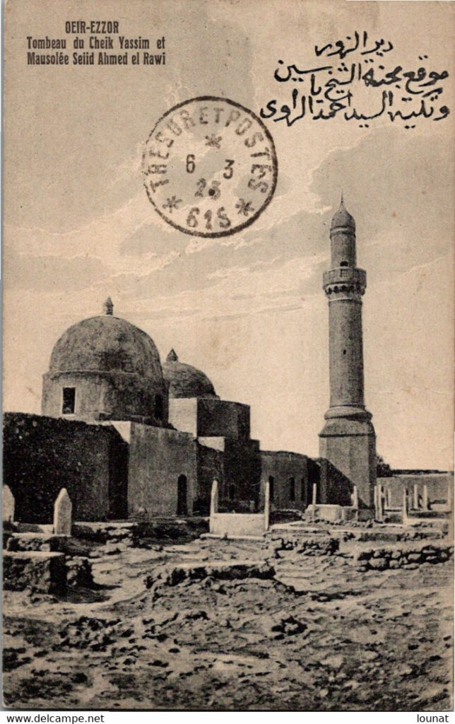
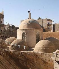
Tekkiyeh al-Rāwī is a modest mosque (zāwiya) located in the heart of Deir ez-Zor, Syria, within the Sheikh Yassin district. The term tekkiyeh, borrowed from Turkish and analogous to a khanqah or zāwiya, has a debated etymology. Some scholars trace it to the Arabic verb ittakā (to lean or rely on), while others associate it with the Turkish notion of rest and comfort—a haven for travelers and wayfarers seeking refuge, food, and rest. French orientalist Clément Huart suggests a Persian origin, connecting the term to the word for leather, recalling the traditional symbolism of Sufi sheikhs who used sheepskin as a spiritual emblem. Construction of Tekkiyeh al-Rāwī began in 1882 and was completed in 1886, under the guidance and personal funding of Sheikh Ahmad al-Rāwī, who endowed the property as a charitable waqf in the name of God and for his descendants. Known for his piety and devotion, Sheikh Ahmad was highly respected by the people of Deir ez-Zor. Tekkiyehs like al-Rāwī have played a vital role in educating generations of youth, strengthening Islamic faith in youth, and fostering social cohesion—especially during the holy month of Ramadan.
The Arched Souq (or The Vaulted Market)

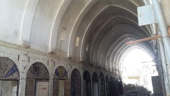
The Old Covered Markets of Deir ez-Zor, locally known as al-Souq al-Maqbi, are a collection of historic commercial marketplaces established in 1865, during the final years of Ottoman rule. They were almost entirely destroyed by bombardment during the Syrian conflict in 2012. These markets were founded under the administration of Khalil Bek Thaqib al-Urfaqli, who, upon being appointed as governor of Deir ez-Zor, invited skilled craftsmen from Urfa to plan and construct the city’s marketplaces. The first among them was Souq al-Miri (the Government Market), which became the nucleus of a growing commercial hub. Due to their artistic, aesthetic, and historical value, and as the only surviving Ottoman-era monument in the city, the markets were officially registered with the Directorate of Antiquities to safeguard this cultural legacy. In 1980, a law was passed to expropriate the old markets as municipal property, yet the shops remained in the hands of their original owners—serving as their primary livelihood. The complex consists of seven ancient markets, all clustered in one area, forming a vital commercial center for the city: • Souq al-‘Attarin (Perfume & Spice Market) • Souq al-Tujjar (Merchants’ Market) • Souq al-Haddadin (Blacksmiths’ Market) • Souq al-Khashabeen (Carpenters’ Market) • Souq al-Hubub (Grain Market) • Souq al-Hibal (Rope Market) • Souq Khalouf (Khalouf Market)