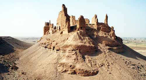


Rising majestically on the banks of the Euphrates River near the city of Al-Mayadin in eastern Syria, Qal’at al-Rahba (The Citadel of Rahba) stands as a monumental reminder of the region’s layered history. Geographically, the site lies at longitude 40.5° E and latitude 35° N, strategically positioned between the ancient cities of Deir ez-Zor to the north and Dura-Europos (Salhiyah) to the south.
The surrounding area is often referred to as Rahbat al-Sham or Rahbat Malik ibn Tawk, a name derived from the prominent Arab leader Malik ibn Tawk al-Taghlibi, who is credited with building the current structure of the fortress during the reign of the Abbasid Caliph al-Ma’mun, around 854 CE. The citadel was constructed to serve both administrative and military purposes, safeguarding this vital point along the Euphrates frontier.
Historical sources and Arab chronicles mention the older settlement as Furdat Nu‘m or simply al-Furda, indicating its long-standing significance as a river port and trading center. The original city of Rahba, located on the right bank of the Euphrates, played a key role in the communication and defense systems of the region.
However, on August 12, 1157, a devastating earthquake struck the region, heavily damaging the cities of Rahba, Hama, and others in its path. Despite such natural disasters, the fortress has remained a symbol of resilience, reflecting the architectural and political heritage of medieval Islamic Syria.